Pic and todays story below, but for those who do not know the trail to everest, here is an itinerary. I've lost track of what day it is..but here is the basics of where we are going...and then back to the regular blog! First day trek, LUKLA2800 meters- Landing here on the small carefully loaded twin otters as you approach you can see a cliff in front of you, the stall alarm sounds and you quickly come to a stop on the uphill landing strip. Lukla Airstrip is port of call for Yaks, porters, Mountaineering expeditions and Trekkers. Goods and people are delivered here in the morning hours prior to the afternoon mountain weather setting in. The trek begins today slowly toward Mt. Everest, following ancient trading routes still used by Rai Magar, Tibetan, Brahmin and Sherpa traders on their way to and from Namche Bazaar. The trail climbs through Mushe and Chaundrikartka at 2680 meters to Chablung, then drops to Ghat at 2550 meters where you spend the night in a quaint little house along side the river. From here on the trek is pretty much up, up, up. Early morning starts in the Khumbu Valley. Rise around 0700, bags packed on the trail at 0800. Today is one of the hardest days of the trek. Walk for 2.5 hours stopping for lunch break in Monjo, gate to the park headquarters. Arrival in Namche Bazaar at 4:00pm. NAMCHE BAZAAR: 3440 meters-Namche Bazaar is a village lying at the junction of the Dudh Koshi and a lateral valley that leads to frontier pass of Nangpa La 5500 meters. It is tucked away in a "bowl" at a height of 3440 meters. The first Europeans entered it in 1950 and many more have come since then. However, the basic character of the village remains unchanged. It has an airplane landing strip high above and a temple with a stream of clear water flowing past it. Prayer flags, inscribed with words "Om mani padme hum" flutter from every rooftop and every house has a cottage industry where Yak wool is spun and woven into carpets. Facilities like a bank, a post office, hotels and shops where one can purchase climbing equipment as well as tinned food have sprung up over the years. Namche Bazaar is the major regional training center, and contains the headquarters of the Sagamartha (Nepalese for Everest) National Park. Day 05: 6 hour hike to help our bodies acclimatize to the new altitudes to endure in the days to come. Visit the Sir Edmund Hillary School in Khumjung. Views of Mt. Ama Dablam, Everest, Nupste and Lhotse . KHUMJUNG- KUNDE: A day hike to Kunde - Home of the Sir Edmund Hillary Hospital Day 06: Begin making the journey up the Everest valley. Walking for about 5 hours directly underneath majestic peaks with Mt. Everest in the distance. Stop for tea at the Ama Dablam guesthouse owned and operated by Lhakpa Dorjee (who summited with the first Canadian on Everest Laurie Skreslet from Calgary) the trail winds along the top of the valley offering incredible views. Lunchtime drop down to the river for lunch at the village of Phunki. This is the last blast of rich air before making our way up to the top of the hill to Tengboche. Tour of the monastery. TENGBOCHE: 3870 meters-or Deboche Thee most famous monastery in all of Nepal is here, the Tengboche monastery. It is one of the important centers of Buddhism in the region. The largest gompa in the Khumba region, it was built in 1921 and then destroyed due to a fire in 1989 and has been carefully rebuilt partly with aforeign aid and volunteers. From Tengboche, one gets a panoramic view of the Himalayan giants Kwandge, Tawache, Everest, Nuptse, Lhotse, Ama Dablam, Kantenga, and Thamserk. Day 07: Today's walk will take you across the Dudh Kosi river, through a rhododendron forest and up to Pangboche for lunch then on to Dingboche. Day 08: Dingboche for the night. Day 09: Start as per normal up at 0700 on the trail by 0800- trek for 4 to 5 hours. The trail climbs to Phalang Karpa at 4340 meters then Dugla (lunch stop) at 4620 meters before reaching Loboche at 4930 meters. The trail looks down on Pheriche (place of the high altitude medical facility). make your way to Lobuche for 2 nights. We will start to feel the effects of altitude now and accommodation is not as comfortable as it was lower in the valley. Day 10: a more aggressive day attempting the summit of Kala Pattar. Non-technical hike, no climbing skills or equipment required. Return to Loboche lodge for nights stay. KALA PATTAR: 5545 metersEVEREST BASE CAMP 5300 meters- Kala Pattar is a small mountain 5545 m high on the southern flank of Pumori (7145m). It is a trekking peak and every year tourists climb the peak to enjoy the fantastic panoramic views it offers of the Khumbu glacier, Everest and nearby peaks like Lhotse and Nuptse. The east Makalu, Ama Dablam, Pumori, and Cho Oyu are visible. From here you can look down onto Everest & Pumori Base Camp, as it is higher. The views of Everest are far superior to being at Everest Base Camp itself. Day 11: Up early 0600 for a full day- 7 hours trekking on the rocky moraine to Everest Base Camp. Upon arrival stay in tents. Meals with the expedition and the excitement of climbers starting to make their summit bids. After that..get the hell out of dodge, down the valley back to lukla and hopefully a plane home. Please read post before these photos..sorry at the internet cafe I am at, it is the only way I can format!

Now at Dingboche.....with everest in upper right corner

Harvesting of potatoes..buried in fall, kept in ground over winter till spring thaw...

Now we change yak styles....now the long hair himilayan yak...much larger...here is one on the trail

The view back down the trail we are going up. This morning clear...but V cold

himilayan goats across the valley

our tea house this morning with everest in center...notice the jetstream vapor trail

The inside of the monastary we visited

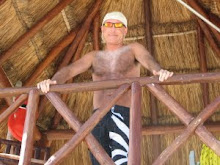
Outside...change of clothes as its getting really cold

More yak photos...amazing beasts
one more...lol

snow as it started, getting hardeer till the valley disappeared
our thundersnow am wake up

Yesterday was a long day. We started with a 2am thunder snow. Woke up to an inch of snow on the ground and cold.Turns out it stayed below freezing the whole rest of the day.Thanks to a little help from Cipro, I am back to my old self and feeling normal again. Just what the doctor ordered! Our hike started in flurries and as we got down the path, it continued to get heavier and heavier. By the time we were heading down to the river we could barely see across the valley. With trail muddy, I managed to take a spill and although I’ll be taking a few advil for the bruised spine, it was my ego that took the beating. I hate to look stupid like that. We enjoyed lunch near the river (Had authentic Dahl Bot...sherpa food of potatoes and veggies, flavored with rice), then crossed another suspension bridge….(this one with hand rails way out to the side so they were useless for those of us who need Zanax to cross these things) and while talking to myself and hyperventilating, managed to get across…only to find the trip leader (Tim) right behind me….busted. So I turn to him and casually say “bet you cant tell that is one of my phobias, can you”. He was kind and said I did fine. Not fine would have been to crumple into a fetal position. After the bridge we followed it up with a 3 hour up to the top of the mountain. We anticipated it to be a very hot day with sun and dehydration to be the big worries, but what really turned out was a whiteout….we could see the ground and all around us but not more than a hundred yards ahead. No heat and dehydration! Top of the mountain was bitter cold and howling winds. Ang Sherpa got us into the local monastery and a special tour. Photos to come. The trip into camp was treacherous with muddy slopes down the path. Unheated rooms (as all this trip) and it went down to somewhere between 15-20 degrees (depending on who was saying what it was). For my birding friends, during the decent a raven was absolutely screaming at me on the trail. I stayed by distance and after a minute or so he hopped onto the trail, then hopped to the far side of it, then took off….3 seconds later I see a hawk swooping after him, jet black, 24” windspan and an Baltimore oriole orange tail. Anyone can you help me on this? Not anything close to the rust color of a red tail….BRIGHT orange. Today was a relatively easy hike of only 6 hours without any epic up or downs. Just what the doctor ordered (reprise because once just isnt enough)! It started out with stars in the sky before bed where I could see every star in the sky. Named a star....NSK...for never eat salad in katmandu....(thing I think got me there) very cold but warmed up to the high 30s by midday with the sun. Wind was strong so a layer change was necessary for the last hour or so of the trip. No wireless internet for the next several days so we hear so this will be posted from a cyber café. Now its snowing again and dropped back down into the 20s before dinner...gonna be a cold trek!
 Now at Dingboche.....with everest in upper right corner
  Harvesting of potatoes..buried in fall, kept in ground over winter till spring thaw...
  Now we change yak styles....now the long hair himilayan yak...much larger...here is one on the trail
  The view back down the trail we are going up. This morning clear...but V cold
  himilayan goats across the valley
  our tea house this morning with everest in center...notice the jetstream vapor trail
  The inside of the monastary we visited
  Outside...change of clothes as its getting really cold
  More yak photos...amazing beasts one more...lol


No comments:
Post a Comment